Posted tagged ‘streets’

North Capitol Street Resurfacing Begins, Work Duration Expected to be Four Weeks

May 17, 2017

For anyone who uses North Capitol Street, here is a heads up that was released yesterday stating that work to resurface North Capitol has begun and is expected to take 4 weeks. The impacted area is from Florida Avenue (south) to New Hampshire Avenue (north). North Capitol is a convenient way to or leave the neighborhood to many points south, so this is sure to impact area drivers during this period.

Text of the DDOT news release can be found here or below:

(Washington, DC) – The District Department of Transportation (DDOT) will begin roadway resurfacing on North Capitol Street today, May 16, weather permitting.

The work, to be conducted from New Hampshire Avenue NW to Florida Avenue NW, is expected to take 4 weeks to complete.

Work will generally be conducted from 9:30 am to 3:30 pm, Monday through Friday; and 7:00 am to 7:00 pm, Saturday; however, certain sections will be worked on from 9:00 pm to 5:00am, Monday through Friday.

During construction, at least one lane will be open in each direction. Curbside parking will not be available on some sections of North Capitol Street during work times. Parking restriction signs will be posted 72 hours in advance at locations where parking will not be allowed. Each sign will list the duration of the restriction and the engineer-in-charge’s contact information.

Variable message signs will be in place to guide motorists. DDOT encourages all motorists traveling through the work zone to stay alert.

DDOT Changing Dumpster Requirements

May 8, 2017

On Thursday, May 4th, DDOT announced that they were making some changes to the requirements for use of dumpsters. The full news release with details is below. I’m happy to see that DDOT is incentivizing the use of smaller dumpsters and limiting the number of parking spaces that can be used per dumpster.  I still think that the District undercharges permit holders for the use of public space in high demand areas, a position I took as part of a resolution I introduced at ANC1A back in July 2015.

DDOT Announces New Requirements for Roll-off-Debris Containers

(Washington D.C.) The District Department of Transportation (DDOT) Public Space Regulation Administration is revising requirements for the use of roll-off-debris containers. These requirements will appear in the Transportation Online Permitting System (TOPS) effective May 19th, 2017.

The new TOPS module will include permit application requirements and the Public Inconvenience Fee (PIF) for larger roll off debris containers on roadways that are designated for Residential Parking Permits.

The new requirements offer an incentive to use smaller containers, which reduce the number of parking spaces affected by use of the containers. Under the new requirements one container will be approved for individual use.

Key enhancements in the new Roll-of-Debris Container module include:

  • Display Height, Length, and Width of containers on issued permits
  • Limit the number of parking spaces occupied by a roll-off-debris container to one (1) parking space for smaller containers and two (2) parking spaces for larger containers
  • Charging the PIF for larger containers that are in place longer than 30 calendar days
  • Additional application review if roll-off debris containers adversely impact parking in residential neighborhoods, or violate public space regulations

No new roll-off-debris container permit applications or renewals will be accepted after May 11, 2017 pending the roll-out of the new module. All roll-off-debris container applications or renewals submitted on or after May 19, 2017 will comply with the new permitting requirements and PIF charges.

DDOT’s new TOPS enhancement is designed to ensure that the impact of roll-off-debris containers in residential areas is reduced, while still allowing this necessary element of the construction process.

The new requirements address concerns raised by residents and reflect input from stakeholder engagement with the development and contracting communities.

For more information about DDOT’s Public Space Regulation Administration please contact (202) 442-4670 or click TOPS (www.tops.ddot.dc.gov) to access the online permitting system.

Could Bioretention Bulbouts Increase Safety and Parking at Park Place and Quebec?

February 8, 2017

Recently I began thinking about how to improve safe access to the small triangle park at Rock Creek Church Rd. and Park Place after a neighbor asked if it would be possible to close the street or add speed bumps to the small section of Park Place that directly abuts the neighborhood on the west of the park. After giving it much though, I think the best solution would be to add a few bioretention bulbouts to the area. However, it would require buy-in from the neighbors and a lot of sustained advocacy from the community. Below is a quick and dirty illustration that conveys the idea.

park-place-bump-outs(Areas outlined in green could be reconfigured as bioretention bulbouts, adding additional green infrastructure and calming traffic.)

The main problem with Park Place minor as it is configured today is that cars using this street take little heed for pedestrians and others as they travel from Rock Creek Church Road to Park Place major. The street is necessarily wide, and the crosswalk and stop sign at the southern end are set back, so as that anyone stopping at the stop sign is too far back from the road to see traffic on  Park Place major. Driver that do stop have to creep to the end of the street to see oncoming traffic — both cars and cyclists in the bike lanes — and this is if they stop at all. Frequently, drivers on this small stretch fail to stop at the stop sign and do a rolling stop as they turn to head south.

Closing the street doesn’t seem to be a good solution either, as the residents who live on the street would lose three parking spaces and it would make it necessarily difficult for delivery vehicles, moving vans, fire trucks, and ambulances to serve the these houses.

Strategic placement of bioretention bulbouts could narrow the entrance and exit of the street to a single lane. The benefit of this is that is would calm traffic and make the crosswalks shorter (and safer) to cross. A bulbout on the southern end of the triangle park would remove one parking space, increasing viability and safety for drivers and cyclists … and the bulbout on the southern end could be configured to add street parking by one to three spaces depending upon configuration.

The only significant down side I see is cost, so there would need to be both consensus among the neighbors most impacted and a sustained advocacy.

Perhaps the way to “sell” this to DDOT, DOEE,& the Council would be to bundle a number of these smaller projecting into a pilot program.

New Street Work Temporarily Stalled

August 19, 2016
Newly paved Manor Place.

Newly paved Manor Place.

I was recently alerted that some of the new paving work that is occurring in the neighborhood hit a temporary setback. Some may have noticed that area streets like Manor Place have recently been repaved. To the west of the Park View School 6th Street is also mostly repaved. However, the 600 block of Newton Place (between 6th and Georgia) has been prepared for new paving but that work has not occurred.

After contacting DDOT, this is what I’ve learned. The installation of the new pavement on Newton has been stymied for the past few weeks due to the paving machine breaking down. The machine is currently being repaired with expectations that it will be repaired soon. Once the repairs are completed, the work on Newton Place will be completed.

Photos of the area around 6th and Newton below:

6th and Newton(Looking north on 6th Street from the intersection of Newton Place.)

IMG_1386(Looking west on Newton Place from 6th Street.)

The District Needs a Long Term Solution for Clean & Safe Bike Lanes

July 6, 2015
Beginning to clean up the gravel in the Warder Street bike lane.

Beginning to clean up the gravel in the Warder Street bike lane.

On June 1st I was alerted to loose gravel in the bike lane at the south end of Warder Street, NW. I presumed this would be an easy issue to resolve and reported it to 311. As it turns out, this was not an easy issue to resolve. After reporting the issue to 311 and then escalating the issue with the Mayor’s Ward 1 representatives in the Office of Community Relations and Services (MOCRS), a month later the loose gravel was still there.

As I’ve dug into this problem, it is my understanding that keeping bike lanes clean of minor but often dangerous debris is a citywide issue. Not being one to let a problem with a simple solution linger, I took it upon myself to clean up the gravel myself. While Warder Street is now clean, there are other bike lanes elsewhere that still need attention. With this in mind, I will continue to work with the city to find a lasting citywide solution to this problem.

In short, I believe that if Washington is going to invest in bike infrastructure, we also need to invest in bike lane safety and maintenance to ensure that these resources are in good repair and safe.

Boese cleanning bike lane
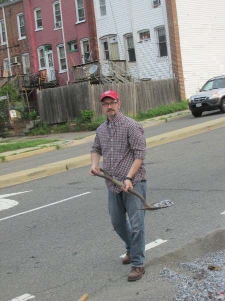
(Commissioner Boese removing gravel from Warder Street bike lane.)

Warder bike lane(Warder Street bike lane with gravel removed.)

2014 USGS Map Shows Road Classifications in Neighborhood

June 10, 2015

Following up on last week’s community meeting with DDOT and my longstanding interest in improving our streets, bike lanes, sidewalks, and tree canopy, I’ve begun a deep dialogue with DDOT asking for a wide range of statistics, funding details, and road history. This will eventually lead to a community task force and collaboration with Advisory Neighborhood Commission 1B’s Transportation Committee. If you are interesting in working with this group, let me know by sending an email to me at 1A08(at)anc.dc.gov.

One aspect of street improvements that has continually been a barrier in past conversations with DDOT has been the classification of our streets. Interestingly, I was able to find a 2014 U.S. Geological Survey map of D.C. which shows the street classifications which I wanted to share. I find it interesting, for example, that Quebec Place, Park Place, and Warder are all classed as local connectors. These streets are widely different in character. None-the-less, its a good place to start in order to begin understanding how we can better manage our public resources in the area.

2014 Park View Map with road classifications(Detail from 2014 USGS map with road classification key below.)

2014 road classification key

Tonight’s Park View UNC Meeting Focuses on Streets/DDOT

June 3, 2015

DDOTI know that there are a good number of people in the neighborhood who care about sidewalks, street configuration, bike lanes, trees, and traffic. I’ve definitely been among them by advocating for a reconfiguration for Park Place, looking for ways to add more trees to treeless blocks, and asking DDOT for a long-term plan to address a number of challenges that can’t be accomplished quickly, such as the tree desert we have in the heart of the neighborhood.

Tonight, the Park View United Neighborhood Coalition has organized a meeting that will include DDOT representatives where these issues and more can be discussed. The meeting will be held at the Park View Recreation Center and begins at 7 pm.

Below is the announcement from from the Park View listserv:

This coming Wednesday, June 3rd, the Park View United Neighborhood Coalition (UNC) has invited speakers from DDOT and the Great Streets program to talk about long-term street planning in our area.

We had initially hoped these speakers could discuss 1) a streetscape plan for Park View that would include widening sidewalks, installing tree boxes, placement of bike lanes, and safety features, as well as 2) past and future opportunities created by the Great Streets program.

Unfortunately, we have learned that contrary to last year’s assertions by DDOT officials, there is no current work being done on a streetscape plan for Park View. The Great Streets program is also not doing work in Park View in the near future (this was less of a surprise to us).

This news makes it all the more important for neighbors to come together at this meeting to talk with city officials about the future of our streets and sidewalks. Representatives from the Mayor’s Office and Councilmember Nadeau will also be present at this meeting, which can help move the discussion forward.

In addition, I would like to note that a representative from the Mayor’s constituent services office will attend to take input from neighbors about alleys and streets in need of repair or resurfacing. If your block needs attention, I suggest you attend!

DDOT Adds Safety Improvements to New Hampshire Median @ Park Road/Monroe Street

January 21, 2015

IMG_7954(New bollards installed to prevent drivers from hitting the median.)

I’m very happy to report that some bollards have been added to the south end of the median at New Hampshire Avenue where it meets Park Road/Monroe Street.

At the November 2014 meeting of ANC 1A, a resident made the commission aware of a problem with the intersection whereby eastbound drivers turning left onto New Hampshire Avenue often hit the median and blew out their tires. This was largely due to the the odd angle of the turn and the lack of visibility for the median.

I alerted DDOT to this issue on November 25th, and am pleased to see that they found a reasonable solution and took action. The photo below shows the median before the installation of the bollards showing chips and markings from vehicles hitting it.

New Hampshire Median

Reassessing Configuration of New Hampshire Avenue ADA Crosswalk Installation Locations

January 9, 2015

New Hampshire crosswalk(Crosswalk across New Hampshire Avenue looking south from the Georgia Avenue Metro station.)

While inspecting the Flexipave work in progress on the New Hampshire Avenue median east of Georgia Avenue, I was reminded of just how illogical the configuration of the crosswalk across that street is. I recall that the Middle Georgia Avenue Great Street project that these crosswalks were part of occurred in 2011. While the crosswalks themselves are nice and wide, the ADA sections are oddly placed and don’t aline. While it seems odd from a pedestrian point of view, it must be frustrating to anyone in a wheelchair as they have to change directions twice to cross the street rather than travel directly across the street in a straight line.

I’ve requested DDOT assess this crosswalk with regards to safety from an ADA point of view. DDOT has agreed to have their lead ADA coordinator and civil engineer in their Infrastructure Project Management Administration review the installation an report back. I’m not expecting a final report quickly, but do have every expectation that DDOT will follow through on this inspection.

Below is an overview of how the ADA crosswalks align for those crossing New Hampshire Avenue between the Metro station and Sweet Mango Cafe.

New Hampshire crosswalk(Plan showing location of ADA cut out in the median with regards to the alignment of the ADA crosswalks on the north and south side of New Hampshire, east of Georgia Avenue.)

Flexipave Being Installed on New Hampshire Avenue Median

January 8, 2015

The median along the 3700 block of New Hampshire Avenue, NW — to the east of Georgia Avenue — is in the process of being reworked. According to the map created by DDOT’s Urban Forestry Administration to track Flexipave work, this is part of that project. A similar section of sidewalk was replaced with Flexipave on Princeton Place back in December. While the Flexipave will not be as attractive as grass, we were likely to never have anything more than barren dirt due to the habit of pedestrians  crossing the street mid-block from the Metro station.

IMG_7943[1](Flexipave work in progress on the New Hampshire Avenue medians.)