Archive for the ‘Streets and Trees’ category

Update on DDOT’s North/South Bike Lane Project

January 31, 2021

DDOT staff presented updates of their plans for protected bike lanes on Park Place, Warder Street, and Kenyon Street at the January 26th ANC1A Transportation Committee meeting. During the meeting they were able to share updated plans for Park Place and Kenyon Street specifically, but are still working on new plans for Warder Street. As such, they were only able to discuss Warder in general terms. The discussion centered on Kenyon Street primarily focused on updates to the current configuration for the 400 block of the street intended to improve safety, but also showed a very early concept to extend the bike lanes west to Georgia Avenue.

DDOT is currently wrapping up their 30% plan design, with the project projected to be at the 60% design phase in late spring or early summer. DDOT hopes to have the plan 100% completed by next winter. Their goal is to begin work on the project as soon as weather permits in the spring of 2022.

One of three design concepts DDOT shared for the redesign of Park Place, NW. This view is looking south of Park Place from Princeton Place.

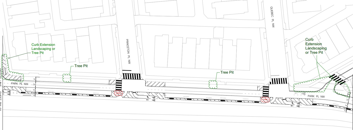
Based on the updated plans that were shared, DDOT is planning to incorporate strategic bulb outs along Park Place to improve intersection safety at several locations, including Park Place minor, Otis Place, Newton Place, and Luray Place. They also are planning to include about 10 new street trees on both Park Place and Warder Street, though specific locations have not yet been selected.

For Park Place, there was some conversation on whether or not the east side of the street should be a protected bike lane and include additional parking, or if instead of parking it should have an on-grade walking path. While there is interest in the walking path option, DDOT was clear that they are still exploring this option and not certain that they could do it.

Detail from the Park Place design set, showing proposed street configuration and bump outs at Park Place (right) and Otis (left).

Lastly, DDOT is agreeable to making Park Road a one-way street. Based on the conversation it appears that the street would be one-way east-bound. This would also allow for double-sided on-street parking along Park Road between Georgia Avenue and Park Place. A contraflow bike lane would also be a part of this configuration.

Residents who have specific questions about this project are requested to communicate to DDOT through their ANC commissions as the fastest way to receive feedback.

You can see the full plan sets presented at the meeting at the following links.

30% Park Place Plan set (January 2021)

30% Kenyon Street Plan set (January 2021)

Update on the Irving/Kenyon Crosstown Protect Bike Lane Project

May 4, 2020

Milling and paving work on Kenyon Street, looking west from Irving Street intersection.

For people who may not be out and about due to the COVID-19 pandemic and Stay-at-Home Order currently in place, you may not be aware of the progress that DDOT is making on the Crosstown Protected Bike Lane project that will connect Brookland and Park View along Irving Street to the north of the Washington Hospital Center.

Those who live near Wangari Gardens or have traveled past the hospitals recently will have noticed that Irving and Kenyon streets east of Park Place have seen a lot of activity with crews milling and paving the streets. This work was in preparation for the crosstown protected bike lanes and appears to be nearly completed.

Due to this progress, DDOT reports that the project to construct the protected bike lanes is on schedule to begin this week. The section where implementation will occur is from Michigan Avenue on the east to Warder Street on the west.

Click here to see the plans from DDOT for the Irving and Kenyon street protected bike lane.

I am also including images below on the Kenyon Street sections as they are the areas neighbors in Park View will be most interested in.

(Paving work on Irving Street)

Changes Coming to the 3500 b/o New Hampshire Avenue this Spring/Summer

January 31, 2020

DDOT is planing to implement some changes to the section of New Hampshire Avenue between Rock Creek Church/Otis Place on the north and Park Road on the south. As the majority of the work will be bollards and stripping, these changes won’t be implemented until the weather gets warmer … meaning that implementation is targeted for Spring/Summer of 2020.

The plans below reflect what DDOT intends to implement and shows locations of bollards, stripping, and new signage that will installed in the area.

Georgia Avenue’s Open Streets Happens on October 5th! Here are the Logistics and Bus Detour Routes You Need to Know

October 2, 2019

The Mayor’s Open Streets DC event on Georgia Ave (Barry Place to Missouri Ave) is coming up this Saturday, October 5, from 10 am to 2 pm. While I’m sure many will come to Georgia Avenue to enjoy lunch, shopping, or just hanging out on Georgia Avenue, here are some details about the day that everyone should be aware of.

Activities: All activities will be free with a focus on fitness and the Mayor’s Vision Zero agenda. The day’s schedule is available online and you can check out an interactive map for locations.

Parking: No parking will be allowed on Georgia Ave from Barry Place to Missouri Avenue starting at midnight on Friday. Cars parked after that time are at risk of being ticketed and towed to another location in the neighborhood. Those whose cars are towed should call (202) 541-6083.

Motorized Access: Unauthorized vehicles will not be allowed to drive on the impacted area starting at 8:00 am (NOTE: This time has changed from 6:00 am). The route and cross-traffic will reopen as soon as it is determined safe by MPD but no later than 5:00 pm.

Sidestreets: Residents and approved vehicles will be allowed to drive and park on side streets one block off of Georgia Avenue. Other cars, including business customers and visitors will be allowed to enter only at the discretion of the MPD officers posted at the entry points.

Crossing Georgia Ave: No unauthorized vehicles will be allowed to cross Georgia Avenue 8:00 am to 5:00 pm except at the discretion of MPD.

Emergency Vehicles: All emergency vehicles will be allowed access to Georgia Avenue and cross streets and a 20-foot fire lane will be maintained on Georgia Ave throughout the event.

Bus Detours: The best source of bus detours is the WMATA website. Below are the detour maps for Routes 62, 63, 64, 70, 79, H2, H4, and H8.

Do You Support Adding Street Trees to the 800 Block of Princeton Place, NW?

September 30, 2019

As anyone who has lived in Park View for a while knows, we have a lot of hot, treeless streets due to a lack of planning when the neighborhood was originally building out. I have had numerous conversations over the years with neighbors who would like to see more trees, and have worked to get more spaces for street trees where ever I find an opportunity.

While out walking last week, it dawned on me that an ideal place to add more trees could be the 800 block of Princeton Place, NW. While it is a short street with only two rowhouses on it, I think every treebox we can create improves the entire neighborhood.

The 800 block of Princeton Place has conditions favorable for adding trees in public space.

What makes the 800 block of Princeton Place promising for adding tree box bump outs is its width and configuration. Currently, it is designated as a one-way street (east bound). It also currently does not allow parking on either the north or south side of the street (although I have seen people park on the south side on more than one occasion). The street is also just over 35 feet wide, meaning that is is over built for the two lanes of traffic it allows.

Measurment in ArcGIS indicates that Princeton Place is 35 feet wide, more than enough for two lanes of traffic and tree box bump outs.

An onsite visit to the street along with reviewing maps indicates that there may be utility infrastructure on the south side of the street, so that leaves the north side open to potential reconfiguration — which is actually better as southbound New Hampshire buses turn onto Princeton Place to travel north on Georgia Avenue.

Below is a rough outline of where curb bump outs could occur on the north side of the street. Depending upon tree selection and planting location, this should create room for 4 to 6 new trees.

Bump outs on Princeton Place could create room for 4-6 new trees, depending upon tree selection and planting location.

While cost is always a factor, when I mentioned this opportunity to some folks at DDOT during a recent meeting, there was some excitement about this. Narrowing the street would improve vehicular safety, narrowing the crossway at Georgia would improve pedestrian safety, and the new trees would increase the overall tree canopy — all DDOT goals.

So what are your thoughts, shall we make this a priority in 2020?


DDOT to Repair Sidewalks on Georgia Avenue from Princeton Place to Ingraham Street, NW, in June

June 5, 2019

Here’s a heads up that I’ve just received, DDOT is scheduled to repair the sidewalks, curbs, and gutters on Georgia Avenue north of Princeton Place beginning later this week or early next week. Full announcement from DDOT below:

The District Department of Transportation (DDOT) will begin repairing the sidewalks, curbs and gutter on Georgia Avenue from Princeton Place to Ingraham Street NW on or about June 7, 2019.

Construction is scheduled to be completed by July 7, 2019, if weather permits.

In order to keep the inconvenience to residents, businesses and their customers to a minimum, the repair work will be done during non-rush hours only.

The contractor is authorized to work Monday through Friday from 9:30 a.m. to 3:30 p.m. The contractor is also authorized to work Saturdays from 7:00 a.m. to 7:00 p.m.

During construction at least one lane in each direction will be open to traffic. However, curbside parking will not be allowed on some blocks of Georgia Avenue NW during the construction working days.

Parking restriction signs will be posted at least 72 hours in advance at locations where parking will not be allowed. These signs will notify the duration of “No Parking”, dates of “No Parking” and contact information of the engineer in charge.

Thank you for your patience and understanding during the repair work. Should you have any problems, concerns or suggestions; please contact me at the information below.

Update on Pepco’s Capital Grid Project & Summer Construction Areas

May 24, 2019

Last night, Pepco held a community meeting to update residents in the general area of Sherman Avenue and Harvard on the status of their Capital Grid project and where to expect construction this summer.

Below is the map that was shared during the meeting. It shows streets where construction has already been completed (green), and where construction will be this summer (blue).

(Pepco maps showing status of completed and future construction.)

The map identifies Sherman Avenue (between Euclid and Girard), Girard Street (between Sherman and 13th), Harvard Street (between Sherman and 13th), and 13th Street (between Girard and Columbia) as the streets where construction will occur. Work will begin between the first week to mid-June 2019 and is expected to be completed by October 1st at the latest.

During construction, each impacted  street will have at least one lane open for traffic. Additionally, on-street parking will be impacted during construction hours, but will be returned to community use when construction ends each afternoon and overnight. Steel plates will also be used to cover the trenches each night.

Here is their list of construction activites:

Pepco Substation No. 13, at Harvard and Sherman Avenue, with 2914 Sherman in the background.

The purpose of all of this work is to transfer the energy service to the neighborhood from Harvard Street to Florida Avenue so that the Harvard Street substation can be brought off-line to be rebuilt.

The current plan is for the Harvard substation to begin construction early in 2020. It is not expected to be completed until late 2022 or early 2023.

It is also important to note that a future section of Pepco Construction will include Georgia Avenue from New Hampshire Avenue to Girard Street, though that is still in the future and not currently scheduled.

(Residents gathered to learn updates from Pepco about their Capital Grid project.)

If Removing On-Street Parking Spaces Also Removed an Open-Air Drug Market, Would That Be a Fair Trade?

April 25, 2019

The 600 block of Newton Place, NW, has been a difficult street for many years. It is narrow. It does not have street trees. And, it has had an on-again, off-again history of open-air drug dealing. We all know that crime is a complicated thing to solve. Clearly, the police play a role, and continue to do so on Newton Place. Social Services also play a key role and we are increasingly identifying public safety issues that are better suited for agencies geared toward addressing addiction and homelessness, as examples.

But what about planning and design? The short answer is yes. Poorly planned roads, streets, and infrastructure can similarly invite criminal activity or at least provide a desirable environment for it.

The 600 block of Newton Place is one area that I believe rises to this threshold.

One recent Saturday as I was walking down the block, I noticed that a brand new Audi A6 was parked on the block, about mid block, with out to District tags. As I was walking, another vehicle with out of District tags parked on the block. The new driver got out of their car and walked up to the Audi where the two then proceeded to conduct a drug transaction. This was shortly before noon.

It got me thinking — if the on-street parking on the block is being used as part of an active drug market, is it serving the community? Moreover, would there be a significant hardship to the neighbors if much of the on-street parking was removed? Even more, if the parking could be removed, could a portion of it be repurposed for street trees on a block where no street trees currently exist.

The overview below shows the area in question. Today, Newton Place is one-way eastbound. There is no parking on the north side of the street and 22 parking spaces on the south side of the street.

(Overview of the 600 block of Newton Place, NW. The red arrow indicates off-street parking currently unused.)

Of the 22 parking spaces currently on Newton Place, I would recommend keeping the five between Georgia Avenue and the entrance to the alley. These support the Ward 1 Senior Wellness Center and the businesses on Georgia Avenue. Also, any resident can park in them afterhours for free. Lastly, as trash and recycling is collected in alleys in Ward 1, keeping the street in its current configuration up to the alley entrance would not create a new hardship for these core city services.

This would leave 17 parking spaces that could potentially be removed. In walking the alleys both north and south of Newton Place, with few exceptions each property has access to off-street parking. Much of it is used, though some of it isn’t. In one case, the apartment building at 636 Newton Place appears to have room for 4 or 5 parking spaces, but the area is fenced off and currently unavailable. This wouldn’t have to stay this way.

(Parking area at the rear of 646 Newton Place, NW, that is currently fenced off.)

In reviewing the current inventory of current and potential alley parking for the properties along Newton Place, about 10 new spaces could be accommodated without significant hardship — this means that the net loss of parking would be 7 spaces.

The question becomes, would losing 7 spaces overall on Newton Place be an agreeable trade off if it also removed the opportunity for out of District vehicles to park there and conduct their drug business on a daily basis?

As a potential bonus, presuming there were wide support for decreasing on-street parking on Newton Place, a portion of the former parking area could be repurposed for about 8 new street trees (see image below).

(Could a portion of the parking on Newton Place be repurposed for new trees?)

As stated at the beginning of this post, Newton is a narrow street currently consisting of one travel lane and one lane of parking. The average width of an American car is 6 feet, meaning that if just 3 feet of the street formerly dedicated to parking were repurposed for a line of street trees, the travel lane would increase in width by 3 feet. The overall result could be a street with less crime, a safer street for travelers, and a more beautiful street with the addition of a tree canopy.

DDOT Issues Notice of Intent to Install HAWK Signal at Georgia and Lamont Street, NW

March 29, 2019

Yesterday, ANC1A received a Notice of Intent from DDOT for the “Installation of New High intensity Activated Crosswalk (HAWK) Signal at the Intersections of Georgia A venue and Lamont Street, NW, NOI 19-85-TESD.” This is very good news as it is part of a longstanding community-led effort to improve pedestrian safety along Park View’s Georgia Avenue corridor.

According to the notice:

The proposed modification is result of traffic analysis performed by DDOT to advance recommendations to improve safety at various pedestrian crossings in Ward 1, as stated in Director Marootian’ s May 4, 2018 letter to Councilmember Nadeau. Original recommendation to relocate the near-side northbound bus stop to far-side of the intersection could not advance due to the presence of loading zone, tree boxes and fire hydrant. Therefore, both the crosswalks at this intersection will be maintained and will be controlled by a new HAWK signal.

HAWK signal control can provide for the safe and efficient movement of vehicular and pedestrian traffic at this intersection, and will provide positive direction to motorists, pedestrians and bicyclists operating through and in the immediate vicinity. The proposed new HAWK signal on Georgia Avenue at Lamont Street, NW, will be timed to operate in harmony with adjacent traffic signals on the Georgia Avenue corridor to minimize disruptions to through traffic.

All comments on this subject matter must be filed in writing by Wednesday, May 8, 2019 (Thirty business days after the date of this notice), with the District Department of Transportation (DDOT), Traffic Engineering and Signals Division at 55 M Street, SE, Washington, D.C. 20003. If you would like to check the status of the Notice of Intent (NOI), please visit DDOT’s website at:
http://ddot.dc.gov/service/ddot-notice-intent. If you have trouble accessing the NOI site or are unable to do so, please contact the DDOT Customer Service Clearinghouse at 202-671-2800.

Here is an explanation from DDOT on how HAWK signals operate.

Time to Report Potholes, Getting Ready for Potholepalooza

March 18, 2019

Pothole on Warder Street in front of the school.

If the streets in Park View are any indicator, it looks like the extreme swings in temperature this winter have resulted in a bumper crop of potholes for the 2019 season. New Hampshire Avenue has a good number and the section of Warder Street in front of the school and recreation center are particularly bad.

This weekend, I took some time to walk the streets, photograph potholes, and report them to the DC 311 system. As potholepalooza hasn’t kicked off yet, this seems like the perfect time to get these requests in so that our streets will be in good repair until next winter.

Many may think of potholes as a nuisance to drivers, but more than that, they can slow down bus service and significantly impact bicycle and pedestrian safety. Potholes in crosswalks, for example, become trip hazards. As noted above, we have some severe potholes in front of the Park View School building and these  need to be a priority on the repair list.

Commissioner Boese out documenting potholes to report to 311 for service.

The map below shows the areas where I found potholes thus far. I haven’t been able to walk every street yet, so if you see one on your street please add it to the 311 system.