Posted tagged ‘historic comparison’

Then and Now: Lithuanian Embassy on 16th Street

January 26, 2017

Recently I found a glass magic lantern slide showing the “Norwegian Ligation” located on 16th Street in 1912 (see below). The Norwegian embassy moved to a new building on Massachusetts Avenue in 1931, where it remains today.

1912-norway-lithuania-embassies(Lithuanian Embassy building on 16th Street in 1912)

Anyone familiar with the building will know instantly that the building in the photo is actually two buildings. the northern half is the Lithuanian Embassy, and the southern half was razed and replaced with a tall apartment building in 1965 which is jarringly incompatible with the surrounding architectural character of the area. However, I think it is easy to miss that the Lithuanian embassy building itself has also had an addition — not just in the rear but also on top. In this way, I think the expansion of the 1907 building was accomplished successfully. It is also good to see that Lithuania is a good steward of its building, and undertook a restoration of the limestone and terracotta facades in 2008, which can be seen here.

lithuanian-embassy-2017
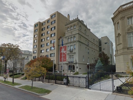
(View of Lithuanian Embassy and abutting apartment building as it appears today)

Then and Now: Pepco’s Harvard Street Substation

November 12, 2015

Here’s a great then and now comparison of the Pepco substation located at Harvard Street and Sherman Avenue. Substation No. 13 was built in 1907 and designed by architect Frederick B. Pyle. Currently, it is Pepco’s oldest operating substation and one of the oldest purpose-built substation buildings still standing. To keep up with demand, additions were also constructed in 1920, 1921, 1929, and 1944.

Below is an image of what it looked like in the late 1950s.

Harvard Substation late 1950s(Image courtesy of Pepco)

Substation No. 13 was the first purpose-built substation constructed outside of the boundaries of the original City of Washington. Compared to other substations built prior to 1929, the Harvard Substation is the most architecturally significant as it is unique in its inclusion of a hipped roof, dormer windows, and stone quoins. These details are likely the result of a two month battle between residents of Columbia Heights and the city which attempted to prevent the substation from being constructed. The resulting building was an attempt to make the building more compatible with the surrounding neighborhood.

Below is what the building looks like today.

IMG_9627

Then and Now: Georgia Avenue and Park Road

August 13, 2015

Georgia and Park Road March 26 1910

The northeast corner of Georgia Avenue and Park Road in 1910 (above) and today (below).

IMG_9231[1]

What the Old Hebrew Home for the Aged Might Have Looked Like

December 19, 2013

I’m in the beginning stages of researching the history of the old Hebrew Home for the Aged building, located at 1125 Spring Road (between 1oth and 13th streets). The building that is currently there was built in two phases. The western wing was completed in 1925 and had 35 rooms for residents. The larger portion of the building was completed in 1953 and increased capacity to 165 residents.

The former Hebrew Home for the Aged from the southeast.

The former Hebrew Home for the Aged from the southeast. The original wing is in the distance with the 1953 addition in the foreground.

One thing I’ve discovered in pulling together the history of the place, interestingly, is that the building was built in stages and never completed. There is still room for an easternmost wing that would have made the building’s Spring Road elevation symmetrical. It also owes much of its current appearance due to the nearly 30 year break between the first wing and the 1953 addition, which caused the 1924 plans to be altered.

From its beginning, the Spring Road Hebrew Home complex was conceptualized to have a residential wing, a hospital wing, and a synagogue. Funding was also an issue that caused construction delays and an approach to build the project in stages.

An early design from 1922 designed by architect Harry A. Brandt shows two large wings sited perpendicular to Spring Road. That design is shown below.

Hebrew Home design 1922(Architectural Sketch of design proposed by Harry A. Brandt, From Washington Times-Herald, December 3, 1922, p. 5.)

Yet, Brandt’s design for a retirement home and hospital may have been too grand when compared to fund-raising efforts. By 1924, when work on the complex finally began both the design and architect had changed. Building permits show that the new architect of the building was Appleton P. Clark, Jr. In looking at the design as reworked, it is clear that Clark added a flair to the design by incorporating Moorish elements. Clark also designed a complex that could be built in stages. The west wing was built in 1924-1925. The eastern hospital wing was planned to follow but delayed due to financial issues. The central, grand synagogue was not built. Below is the design as envision by Clark.

(Architectural Sketch of Appleton P. Clark, Jr.’s design, From The Evening Star, June 14, 1924, p. 16.)

In looking at Clark’s design, it is easy to see that the western wing of his design closely resembles the original 1925 Hebrew Home structure. Deviation from Clark’s design when construction began again in 1953 was likely due to the Home’s need for more capacity than that anticipated in 1924.

Historical Society of Washington, D.C.’s Urban Photography Series 2013 Neighborhoods

October 4, 2013

Earlier this year, I participated in the Historical Society of Washington’s Urban Photography series as a tour guide. The purpose of the tours was to explore one neighborhood in each of Washington’s 8 Wards and create a photographic record of that community today. These photographs have been added to the Historical Society’s collection and will be useful to future scholars writing about our city.

It is hoped that the Urban Photography Series will occur annually and eventually document every corner of the District of Columbia. Below is a video that the HSWDC put together that will give you a taste of was was accomplished this year.

Enjoy.

Then and Now: 3642 Georgia Avenue, NW

May 13, 2011

Miami Seafood Grill 19483642 Georgia Avenue

(The northwest corner of Princeton Place and Georgia avenue in 1949 (left) and 2011 (right))

Though there is an old adage that a picture is worth a thousand words, sometimes a picture creates more questions than answers. The picture above from 1949 is one such picture. It shows the northwest corner of Princeton Place and Georgia Avenue, with 3642 Georgia Prominently located front and center.

Ad for Scotty's Restaurant from the Washington Post, April 11, 1937

In looking at the photograph the Miami Seafood Grill is right on the corner with a Safeway just to the north and the back of the Peoples Drug Store after that. What is vexing to me is that I haven’t been able to find out much about the restaurant. The building at 3642 dated to 1911 when E.M. Dulin erected the brick store valued at $7,000.

The photograph above shows that it had become the Miami Seafood Grill by 1949 but I haven’t been able to find out any additional information on this restaurant (so far) which is a shame. It looks like it had a great neon sign including palm trees. The only other piece of information I’ve been able to find is a matchbook cover dating to sometime after 1952, judging by the “Randolph 6-” phone number. You can see a picture of that below.

Share

Then and Now: Decatur Street Car Barn

April 8, 2011


Car barn 1907Car barn 14th street

(The new car barns of the Capital Traction Company on “Fourteenth Street Extended” in December 1907 (left) and today (right))

We haven’t really heard anything of substance about streetcars on Georgia Avenue since the middle of last year. With the way the District budget is shaping up it’s likely to be years before it happens, if it happens at all. Yet, one thing I’ve been curious about since DDOT first proposed a city-wide streetcar system is where the trains will actually be housed when not in use.

The old car barns on Georgia Avenue, which were transformed into Curtis Chevrolet, are currently going to be raised to make way for Walmart and the car barns on East Capitol Street are now condos. The Decatur Street car barn (above) at 4615 14th Street, NW, would make an excellent facility in the area — except it isn’t located on any of the proposed lines.

The Decatur Street car barn dates to 1907 and was considered an architectural gain for the District. Architects Wood, Donn & Deming designed the structure for the Capital Traction Company which wanted their new facility to be in keeping with the residential architecture in the surrounding neighborhood. The finished barns accommodated over 250 streetcars. Today it is WMATA’s Metrobus Northern Division garage.

View from the interior of the car barn toward 14th Street, 1961

Share

Then and Now: 3626 Georgia Avenue

March 30, 2011

3626 Georgia Avenue 19153626 Georgia Avenue 2011

(3626 Georgia Avenue in 1915 (left) and today (right))

There have been a lot of changes to Georgia Avenue over the years, and a topic that is on the minds of many as development looms on the horizon for the area is housing. Not surprisingly, this is not a new issue. Much of lower Georgia Avenue was originally lined with residences and much of middle Georgia Avenue still is.

Occasionally you can see traces of the former residential corridor looming behind or above current store fronts. One such place is at 3626 and 3628 Georgia Avenue as can be seen to the right. These two remnants are from a row of houses built in 1915 by Charles L. Tankersley. The previous year, Tankersley had built the houses on New Hampshire Avenue between Otis Place and Spring Road.

As you can see from the real estate ad below, published in the Washington Times, April 24, 1915, these properties originally sold for $3,750 and had monthly payments of $27.50.

Share

Then and Now: Snow Plows

December 27, 2010

Snow plows ca. 1925Snow Plows at RFK Stadium by DDOTDC, on Flickr

District snow plows, then and now. Left: Ford Motor Company snow plow equipment ca. 1925 in front of the District Building. (Photo courtesy of the Library of Congress collection). Right: DDOT snow plows in front of RFK stadium, November 5, 2010. (Photo from the DDOTDC flickr pool).

The image below is also from the DDOTDC flickr pool, and shows a Caterpillar Industrial Loader used in snow removal efforts from February 9, 2010.

Snow Removal

Share

Then and Now: New Hampshire and Rock Creek Church Road, NW

December 10, 2010

3600 New Hampshire Avenue ca 19273600 New Hampshire Avenue 2010

(The northwest corner of New Hampshire Avenue and Rock Creek Church Road, NW, ca. 1927 (left), and today (right). Historic image from Historical Society of Washington, D.C.)

The houses located on the west side of New Hampshire Avenue from 3600 to 3612 were built by Joseph J. Moebs. Construction began in 1909. Upon purchasing the land from Ernest Steiger for $7,800, some speculated that Moebs would erect an apartment house instead of residences . This view shows the row from the southeast, at the intersection of New Hampshire and Rock Creek Church Road.

Share