Archive for the ‘Transportation’ category

Update on AFRH Zone A Development

June 6, 2022

Development Plan for AFRH Zone A showing location and configuration

On Thursday, June 2, 2022, the National Capital Planning Commission (NCPC) had a public meeting for an amendment to the Armed Forces Retirement Home’s (AFRH) Zone 1 development plan. Neighbors have long desired that any development at the AFRH would lead to increased access to green space. While Urban Turf has briefly covered this meeting, this is a good opportunity to share my thoughts on the develpment and next steps.

Overview

In short, I remain deeply disappointed and underwhelmed by the AFRH development plan and dispite the many successful community events that the Friends of the Soldiers Home has organized on their grounds, the AFRH leadership seems to be reverting to a position of resisting community access. In my assessment, this will only change with strong community involvement moving forward.

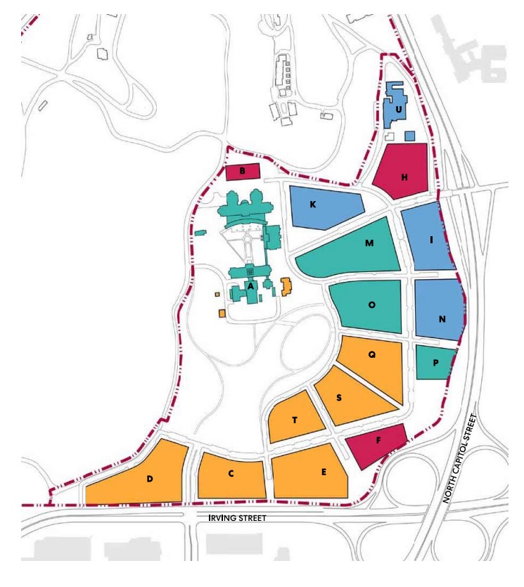
On June 2, 2022, the National Capital Planning Commission reviewed an amendement to the AFRH Zone A master plan. This is the large development that has been in the works for over a decade and is located near the cloverleaf at Irving and North Capital Street (see image above). Only three people testified before the NCPC: myself, ANC4C Commissioner Jonah Goodman, and John Hughes of the Friends of the Soldeirs Home. No one testified from Ward 5.

All three of us testified that a significant flaw in the development plan is the lack of community access to the neighborhoods to the west and north. While the AFRH has talked a good game about creating public green space as part of their development, I pointed out in particular that the development plan makes it clear that the green space is not designed as a benefit to the neighbors living here now, but instead as an amenity to residents they hope will move to their development. The configuration and massing of the planned buildings clearly convey that for all intents and purposes this is a “gated community” without the fence and gate.

Many of the NCPC Commissioners heard this position loud and clear. While they approved the amendment, the also included the following request in their report (read full report here).

Requests: that AFRH re-engage with NCPC staff, the District of Columbia Office of Plannign, the National Park Service, and the community to evaluate the feasibility of possible public access through the western portion of the AFRH Zone (golf course and open space) as part of a future AFRH submission for the golf course and open space.”

It was clear at the hearing that AFRH leadership was disappointed that the issue of public access was raised and it was clear that they did not expect testimony criticising their development. It was also clear to me that the community needs to organize and mobilize to have a strong voice and push the needle on this.

Next Steps

While the NCPC voted to approve the Zone A amendment, there will be several key areas where community members can, and need to, be involved — these include Zoning and Historic Preservation approvals. Both will require public hearings where all interested neighbors can and need to engage. The development plan is not far enough along for hearings to be scheduled for either yet, so this is something that we all need to monitor.

While the AFRH leadership clearly doesn’t see how “their development” concerns the greater community, they are mistaken. By designing a car-centric, disconnected neighborhood in an area with poor access to public transportation, the 3,000+ residential units they hope to construct will have a significant negative impact on general quality of life, especially with traffic and polution. It is in their best interest to create stronger pedistrian and bike connections to Park View and Petworth to mitigate those impacts. This is a win/win approach that not only would provide neighbors with better access to green space, but also meet the future demand of the over 3,000 residents that  AFRH hopes to bring to the area. 

I believe the time has come for neighbors to again re-engage and push back. I will be working with my ANC collegues and other community leaders to determine the timeline for engagement and opportunities for feedback. I’ll repost again when I have more information to share on this front.

Update on DDOT’s North/South Bike Lane Project

January 31, 2021

DDOT staff presented updates of their plans for protected bike lanes on Park Place, Warder Street, and Kenyon Street at the January 26th ANC1A Transportation Committee meeting. During the meeting they were able to share updated plans for Park Place and Kenyon Street specifically, but are still working on new plans for Warder Street. As such, they were only able to discuss Warder in general terms. The discussion centered on Kenyon Street primarily focused on updates to the current configuration for the 400 block of the street intended to improve safety, but also showed a very early concept to extend the bike lanes west to Georgia Avenue.

DDOT is currently wrapping up their 30% plan design, with the project projected to be at the 60% design phase in late spring or early summer. DDOT hopes to have the plan 100% completed by next winter. Their goal is to begin work on the project as soon as weather permits in the spring of 2022.

One of three design concepts DDOT shared for the redesign of Park Place, NW. This view is looking south of Park Place from Princeton Place.

Based on the updated plans that were shared, DDOT is planning to incorporate strategic bulb outs along Park Place to improve intersection safety at several locations, including Park Place minor, Otis Place, Newton Place, and Luray Place. They also are planning to include about 10 new street trees on both Park Place and Warder Street, though specific locations have not yet been selected.

For Park Place, there was some conversation on whether or not the east side of the street should be a protected bike lane and include additional parking, or if instead of parking it should have an on-grade walking path. While there is interest in the walking path option, DDOT was clear that they are still exploring this option and not certain that they could do it.

Detail from the Park Place design set, showing proposed street configuration and bump outs at Park Place (right) and Otis (left).

Lastly, DDOT is agreeable to making Park Road a one-way street. Based on the conversation it appears that the street would be one-way east-bound. This would also allow for double-sided on-street parking along Park Road between Georgia Avenue and Park Place. A contraflow bike lane would also be a part of this configuration.

Residents who have specific questions about this project are requested to communicate to DDOT through their ANC commissions as the fastest way to receive feedback.

You can see the full plan sets presented at the meeting at the following links.

30% Park Place Plan set (January 2021)

30% Kenyon Street Plan set (January 2021)

Update on the Irving/Kenyon Crosstown Protect Bike Lane Project

May 4, 2020

Milling and paving work on Kenyon Street, looking west from Irving Street intersection.

For people who may not be out and about due to the COVID-19 pandemic and Stay-at-Home Order currently in place, you may not be aware of the progress that DDOT is making on the Crosstown Protected Bike Lane project that will connect Brookland and Park View along Irving Street to the north of the Washington Hospital Center.

Those who live near Wangari Gardens or have traveled past the hospitals recently will have noticed that Irving and Kenyon streets east of Park Place have seen a lot of activity with crews milling and paving the streets. This work was in preparation for the crosstown protected bike lanes and appears to be nearly completed.

Due to this progress, DDOT reports that the project to construct the protected bike lanes is on schedule to begin this week. The section where implementation will occur is from Michigan Avenue on the east to Warder Street on the west.

Click here to see the plans from DDOT for the Irving and Kenyon street protected bike lane.

I am also including images below on the Kenyon Street sections as they are the areas neighbors in Park View will be most interested in.

(Paving work on Irving Street)

DDOT Hosting Ward 1 Transportation Meeting on Saturday!

November 13, 2019

DDOT is hosting a public event to let residents engage directly with the agency to learn more about its projects in Ward 1. Relevant information is listed below

Who: Ward 1 residents and The District Department of Transportation (DDOT)
What: DDOT’s Ward 1 Open House
When: Saturday, November 16, 2019 from 12:00PM-2:00PM
Where: Columbia Heights Community Center (1480 Girard Street NW)
Why: To educate, engage and inform residents of what’s happening in the community

Residents may be particularly interested in the 14th Street Bus information that was discussed at ANC Transportation Committee meetings.

Georgia Avenue’s Open Streets Happens on October 5th! Here are the Logistics and Bus Detour Routes You Need to Know

October 2, 2019

The Mayor’s Open Streets DC event on Georgia Ave (Barry Place to Missouri Ave) is coming up this Saturday, October 5, from 10 am to 2 pm. While I’m sure many will come to Georgia Avenue to enjoy lunch, shopping, or just hanging out on Georgia Avenue, here are some details about the day that everyone should be aware of.

Activities: All activities will be free with a focus on fitness and the Mayor’s Vision Zero agenda. The day’s schedule is available online and you can check out an interactive map for locations.

Parking: No parking will be allowed on Georgia Ave from Barry Place to Missouri Avenue starting at midnight on Friday. Cars parked after that time are at risk of being ticketed and towed to another location in the neighborhood. Those whose cars are towed should call (202) 541-6083.

Motorized Access: Unauthorized vehicles will not be allowed to drive on the impacted area starting at 8:00 am (NOTE: This time has changed from 6:00 am). The route and cross-traffic will reopen as soon as it is determined safe by MPD but no later than 5:00 pm.

Sidestreets: Residents and approved vehicles will be allowed to drive and park on side streets one block off of Georgia Avenue. Other cars, including business customers and visitors will be allowed to enter only at the discretion of the MPD officers posted at the entry points.

Crossing Georgia Ave: No unauthorized vehicles will be allowed to cross Georgia Avenue 8:00 am to 5:00 pm except at the discretion of MPD.

Emergency Vehicles: All emergency vehicles will be allowed access to Georgia Avenue and cross streets and a 20-foot fire lane will be maintained on Georgia Ave throughout the event.

Bus Detours: The best source of bus detours is the WMATA website. Below are the detour maps for Routes 62, 63, 64, 70, 79, H2, H4, and H8.

More Bike Racks Installed (and Coming) to the Park View School

April 29, 2019

For the past month, I’ve been working to get more bike racks installed at the Bruce-Monroe @ Park View School on Warder Street. This was in response to a request from parents and school administration. I’m happy to report that two new bike racks were installed about a week ago in front of the building on Warder Street.

(The two blue bike racks are new additions and double the number of racks currently serving the school.)

I’m happier to report that the racks are already being used, as you can see from the photo below sent to me by one of the happy parents.

In order to get the racks, I met with DDOT’s Bicycle Support Specialist and walked the grounds. We identified about four different locations where new racks could be installed, with some locations requiring more time due to needing to order equipment.

In addition to the two new racks on Warder Street, I’m continuing to work with DDOT to get an additional rack or two on the south side of Otis Place just west of Warder in the parking area. It shouldn’t create any issues with the street trees, but does require a different type of rack than what DDOT had on hand. These racks could be installed later this spring.

(Area were additional rack can be added in the near future.)

DDOT Issues Notice of Intent to Install HAWK Signal at Georgia and Lamont Street, NW

March 29, 2019

Yesterday, ANC1A received a Notice of Intent from DDOT for the “Installation of New High intensity Activated Crosswalk (HAWK) Signal at the Intersections of Georgia A venue and Lamont Street, NW, NOI 19-85-TESD.” This is very good news as it is part of a longstanding community-led effort to improve pedestrian safety along Park View’s Georgia Avenue corridor.

According to the notice:

The proposed modification is result of traffic analysis performed by DDOT to advance recommendations to improve safety at various pedestrian crossings in Ward 1, as stated in Director Marootian’ s May 4, 2018 letter to Councilmember Nadeau. Original recommendation to relocate the near-side northbound bus stop to far-side of the intersection could not advance due to the presence of loading zone, tree boxes and fire hydrant. Therefore, both the crosswalks at this intersection will be maintained and will be controlled by a new HAWK signal.

HAWK signal control can provide for the safe and efficient movement of vehicular and pedestrian traffic at this intersection, and will provide positive direction to motorists, pedestrians and bicyclists operating through and in the immediate vicinity. The proposed new HAWK signal on Georgia Avenue at Lamont Street, NW, will be timed to operate in harmony with adjacent traffic signals on the Georgia Avenue corridor to minimize disruptions to through traffic.

All comments on this subject matter must be filed in writing by Wednesday, May 8, 2019 (Thirty business days after the date of this notice), with the District Department of Transportation (DDOT), Traffic Engineering and Signals Division at 55 M Street, SE, Washington, D.C. 20003. If you would like to check the status of the Notice of Intent (NOI), please visit DDOT’s website at:
http://ddot.dc.gov/service/ddot-notice-intent. If you have trouble accessing the NOI site or are unable to do so, please contact the DDOT Customer Service Clearinghouse at 202-671-2800.

Here is an explanation from DDOT on how HAWK signals operate.

DDOT Reviewing Potential Bikeshare Station for Central Park View

March 5, 2019

DDOT continues to review locations to expand their Capital Bikeshare program to meet growing community demands for the service. They have identified a new location that looks promising — the northeast corner of Morton Street and Georgia Avenue. Based on DDOT’s preliminary review, there are no parking or traffic impacts to installing a station at this location because it is not in the roadway. The sidewalk is 12 feet wide, so with the bikeshare station installed there would be a six foot pedestrian travel lane, which meets the standards in the Americans with Disabilities Act.

I know that a location in central Park View has been something that many have wanted for years, so the location helps meet that demand as well. The station would be placed next to “Adventure Dental” on the Morton Street side. The following photos provide a better idea of where the station could go.

DDOT Planning to Establish No-Right-On-Red at 101 DC Intersections

December 31, 2018

On December 21st, the District Department of Transportation notified Advisory Neighborhood Commissioners across Washington that they plan to establish No-Turn-on-Red restrictions at 101 signalized intersections across the city. These intersections were identified based on factors and criteria identified in the federally mandated Manual on Uniform Traffic Control Devices and the DC Municipal Regulations, which identify factors including an intersection’s complexity, level of pedestrian activity, potential for significant conflicts, and crash history, to name a few.

Intersection of New Hampshire Avenue, Georgia Avenue, and Rock Creek Church Road, NW

In reviewing the list of intersection where DDOT intends to make this change, the areas in and closest to Park View include the following signaled intersections:

  • Georgia Ave., New Hampshire Ave., & Rock Creek Church Rd.
  • Georgia Ave. & Otis Place
  • Georgia Ave. & Randloph St.
  • 14th St. & Columbia Rd.
  • 13th St. & Kenyon St.
  • 14th St. & Kenyon St.

Drivers will want to pay attention to all impacted intersections, though, as intersections further away from the area also will have an impact. I’ve mapped out the impacted intersections based on the DDOT list as many may find the information in map form more useful.

Overall, I like the directly DDOT is going with this as it has been my observation that many who turn right on red are more focused on seeing if the coast is clear of oncoming traffic and not always paying attention to pedestrians and others who are in crosswalks they are turning onto.

That said, I hope DDOT will use this opportunity to evaluate if a better city-wide policy is needed. I’m not entirely convinced that drivers will be able to remember which intersections will allow and which will deny them the opportunity to turn right-on-red. I’m equally doubtful that there is a solid plan for enforcement. For example, the intersection of Georgia Avenue, New Hampshire Avenue, and Rock Creek Church Road already does not allow left-turns at any time and signs are clearly posted — yet I have seen drivers do this with no consequences beyond drivers behind them using their horns and expressing anger as they pass by.

Intersection of Georgia Avenue and Otis Place, NW


Community Meeting on Warder & Park Place Bike Lanes this Wednesday, Nov. 7th!

November 5, 2018

DDOT has been working on plans to install protected bike lanes on Park Place, Warder Street, and the 400 block of Kenyon St. as part of their implementation of the Crosstown Multimodal Transportation effort. These bike lanes would connect Park View to Brookland by expanding the current bike lane network.

In collaboration with ANC1A, DDOT will be the featured guest at the Wednesday, November 7th Park View UNC meeting where they will provide an overview of the project and be available for questions and feedback on their current proposal. Among the ideas that DDOT is considering is additional on-street parking on Park Place and tree bump outs on Warder Street.

Please see the flyer below and check out https://www.dccycletrack.com/crosstown for additional information.